IMD Model Cyclone big update: Odisha’s Paradip may record 80cm rain, landfall likely in West Bengal!
Published By : sanjeev
| October 8, 2025 7:11 PM
By Sanjeev Kumar Patro
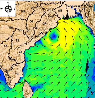
Bhubaneswar: Bay of Bengal will be brewing a cyclone next week for sure. A low level cyclonic circulation over the Andaman seas can be seen from the satellite image above (Japan’s Himawari satellite). Under its influence a low pressure area will be formed over the region in the next 24-36 hours. As per(IMD) has forecasted heavy rainfall in several districts of Odisha from October 23-25.
Post the formation of low pressure area over the Andaman seas, on and around October 20, the system will track west to reach the central Bay of Bengal, where the system will intensify or say cyclone genesis will take place. Analysis of all the weather models available indicates that the system will intensify into a cyclonic storm by Oct 22/23.
While the weather models of ECMWF, NCUM-G, ACCESS see the cyclonic system tracking northwest in the bay and taking a hit at the State Of Odisha on October 23/24, IMD –GFS model predict the system tracking north-northwest in the bay and will brush past the coastal areas of Odisha like Jagatsinghpur/Paradip on October 26/27 to make land fall in West Bengal on October 29.
The weather model of NOAA NCEP-GFS agrees with the IMD –GFS model on the place of landfall and impact on Odisha, but the model predicts the landfall date on October 24/25.
INDIAN MODEL FORECASTS
There are three Indian models that predict on the probable cyclone genesis in the Bay of Bengal. While the national weather forecaster IMD has its model – IMD-GFS, the National Centre for Medium Range Weather Forecast’s (NCMRWF) has the NCUM-G and INCOIS has its ocean state forecast model.
A study of the 3 Indian models clearly hints at cyclone brewing in the Bay of Bengal. All the Indian models, as on today, don’t see the system intensifying into a very severe cyclone. The wind speed predicted is around 65-80kmph.
A detailed analysis of the three Indian models brings out the following on its impact and landfall place.
INCOIS model predict the cyclonic storm tracking northwest will make landfall around Goplapur – Chatrapur – like that of Cyclone Phailin in 2013
NCMRWF’s NCUM-G predicting the track and landfall on the same line as that of INCOIS. The model forecast predict the system tracking along the inside edge of an upper atmospheric ridge that extends up to Arabian sea from the Gulf of Thailand.
IMD’s GFS model also sees the cyclonic system tracking alongside the inside edge of an upper tropospheric ridge that extends from over the Myanmar and passing over Odisha and West Bengal.
The IMD GFS model, therefore see the system taking north turn as it closes in to Odisha coasts.
The IMD model forecast is the upcoming cyclonic system will brush past Odisha’s Paradip and Jagatsinghpur area to make landfall in West Bengal on October 29.
The IMD model sees slow movement of the system and remaining over the seas for a longer period.
GLOBAL MODEL ANALYSIS
An analysis of three reputed global tropical cyclone forecasting models like ECMWF, NOAA-GFS and Australia’s ACCESS reveals the following.
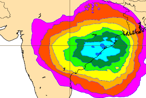
ECMWF model see the cyclonic system tracking northwest to make landfall around Gopalpur – Chhatrapur on October 24/25. ECMWF claims it is 80% sure that the system will take a hit at Odisha's Gopalpur - Chatrapur. (See the image above)
The United States’ NOAA GFS model agree with IMD-GFS forecast analysis.
The NOAA-GFS model sees the cyclone tracking north-northwest to brush past Odisha’s Paradip-Jagatsinghpur to make landfall in West Bengal (Sagar Islands) on October 24/25.
Australian model ACCESS agree with north-northwest track, but the model see the cyclonic system making landfall in Odisha between Paradip and Balasore on October 24.
The model predicts high impact on the state of Odisha. It also sees the system intensifying into a severe cyclone.
WEATHER ANALYSIS OBESRVATIONS
A study of all the model forecasts – both Indian and global – leads to the following conclusion.
Cyclone is brewing in Bay of Bengal for sure.
The cyclone will be tracking northwest in its initial days.
The cyclone will come close to Odisha coasts
Odisha impact looks certain.
But extent of impact depends on landfall, where unanimity is completely missing.
IMD MODEL ANALYSIS
An analysis of the IMD-GFS model brings to fore the following observations.
The system will bring rains over Odisha from October 24 onwards.
Heavy rain forecast on 26,27,28 in Bhubaneswar (10cm), Cuttack, Bhadrak on October 26/27
Paradip may record 80cm rain on Oct 27/28
Chandbali may see rainfall in the range of 40 cm on Oct 26/27/28
Jagatsinghpur may record rainfall in the range of over 23 cm on Oct 27/28