


Bhubaneswar: The pre-monsoon cyclone genesis seems to start early this Year (2025). The first week of April would see formation of a cyclonic circulation over south Bay of Bengal.
While the NCMRWF’s NCUM model has not predicted any probability of cyclone genesis during the first week of April, IMD GFS and IIITM models are predicting cyclone genesis during the first week of April.
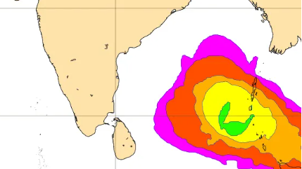
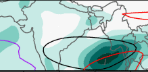
The IITM model predicts a 50% probability of cyclone genesis over the south Bay of Bengal. Based on the initial conditions of March 29, the IITM model predicts the system charting west direction post formation. (see the image below)
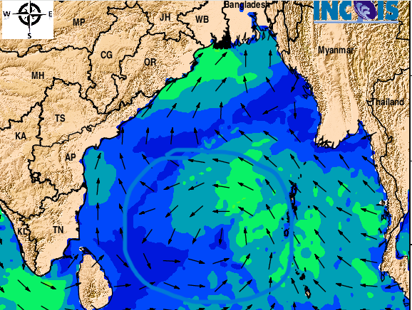
The Integrated Indian Ocean Forecast system of INCOIS has also predicted development of a cyclonic circulation over south Bay of Bengal. (see the image below)
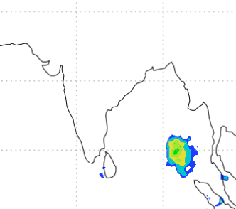
The NCEP CFS forecast shows the presence of equatorial Rossby waves will be aiding in the formation of cyclone genesis in the south Bay of Bengal and Andaman seas. The CFS has also predicted MJO over north Indian Ocean. (see the image below)
IMD FORECAST
The national weather forecaster has assigned around 33% probability of cyclone genesis during the first week of April over south Bay of Bengal and Andaman seas.
The IMD analysis says, MJO will not aid convectivity or cyclone genesis in the first week of April.
However, based on the same NCICS CFS model forecast, the IMD says:
- The weak easterly anomaly is likely to spread over the southern parts of BoB and adjoining southeast AS during second half of week 2
- The zonal wind anomalies and equatorial waves may support development of cyclonic circulation over Equatorial Indian Ocean (EIO) and adjoining south BoB during first half of week 1 (March 28-April 3)
- Negative Indian Ocean Dipole condition is prevailing over the region which is favourable for cyclogenesis over the BoB.
IMD MODEL: IMD GFS is indicating a cyclonic circulation over southwest BoB around 5th and 6th April.
- Intensifying into a depression by April 7
- This IMD model forecast the system to chart northwest direction
- The model predicts the system to dissipate over Krishna-Guntur region of Andhra Pradesh
- IMD ERF(extended range model forecast) cyclogenesis guidance is also indicating no potential zone during week 1 and 10-20% probability of cyclogenesis over central parts of south BoB during week 2(April 4-10).
OTHER MODEL FORECASTS
- US-based NCEP GFS predict a low pressure area over Andaman Sea around April 5, the system will move northwestwards towards east central BoB, and intensify into a cyclonic storm over central BoB around April 7
- Post cyclone formation, the system will take a northeastwards recurvature towards Myanmar.
- ECMWF: Predicts a low pressure area over North Andaman sea around April 3.
- To move west-northwestwards and intensify into a depression by April 5
- Intensify into a cyclonic storm by April 6.
- The model indicates the system to move towards westcentral BoB off South Andhra and adjoining North Tamil Nadu till April 8
- Recurve north-northeastwards thereafter and dissipate off North Andhra Pradesh coast by April 9.