


A powerful earthquake struck Myanmar's Sagaing Region on March 28, 2025, with effects felt in Thailand and China. This major seismic event caused widespread devastation and is considered a significant one in Myanmar's history. This brief details the earthquake, its geological context, historical seismicity, and its broader implications.
2025 Sagaing Earthquake:
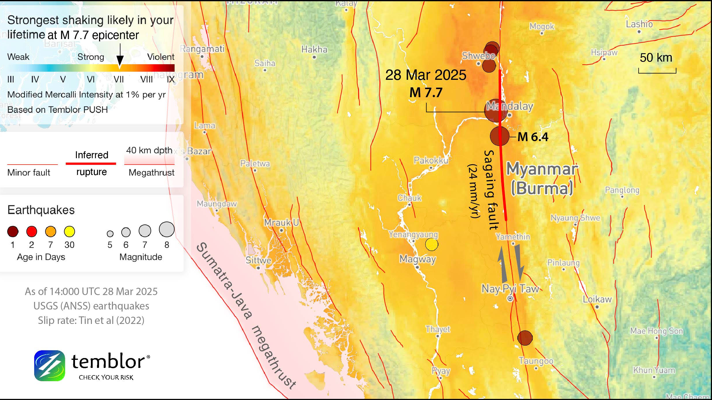
On March 28, 2025, at approximately 12:50 PM local time in Myanmar (06:20:54 UTC), a magnitude 7.7 earthquake (Mw, USGS & INGV; other agencies reported 7.9-8.2) occurred in the Sagaing Region.
The epicenter was near Mandalay. The USGS located it at approximately 21.996°N latitude and 95.926°E longitude, and INGV at 21.8109°N and 95.8604°E. The earthquake's depth was shallow (USGS: 10 km, INGV: 17 km), increasing its destructive power.
The earthquake caused substantial damage in Myanmar, especially in the Sagaing Region, Mandalay, and Naypyidaw. Over 2,600 people died, thousands were injured, and many are missing. Infrastructure was severely compromised, with collapsed buildings, including homes, businesses, and religious structures. Transportation and public service facilities were damaged. Mandalay International Airport was damaged, and key roadways, including the Yangon-Nay Pyi Taw-Mandalay expressway, were disrupted.
The earthquake also caused power outages, water service disruptions, and communication network instability. Landslides were reported. The earthquake's impact extended beyond Myanmar. In Bangkok, Thailand, strong tremors caused buildings to sway, triggering panic. A building under construction collapsed, resulting in 10 to 17 deaths. Tremors were also felt in Yunnan, China, causing some house damage and injuries. A series of aftershocks followed, including a significant one initially measured at magnitude 6.4, later revised to 6.7 (Mww). Aftershocks are expected to continue for several months. A strong aftershock shortly after the initial earthquake increased risks to damaged structures and rescue efforts.
Geological Setting of the Sagaing Region
Southeast Asia's geological landscape is dynamic, situated at the intersection of the Indian, Eurasian, Sunda, and Burma microplates. The northward movement of the Indian Plate and its collision with the Eurasian Plate have formed the Himalayas and drive tectonic activity. The Burma microplate is located between the Indian Plate to the west and the Sunda Plate to the east.
The Sagaing Fault, a major geological feature in Myanmar, runs north-south for 1,200 to 1,400 kilometers. It is a right-lateral strike-slip fault. It accommodates regional tectonic movements, specifically the northward motion of India and western Myanmar relative to Southeast Asia, including the Sunda Plate. The slip rate along the Sagaing Fault is estimated to be around 18 millimeters per year. The Sagaing Fault connects the Andaman Sea in the south to the Himalayan collision zone in the north. The 2025 earthquake likely occurred along this fault.
The region is also influenced by the Sunda Megathrust, where the Indian Plate subducts beneath the Burma Plate, a major source of earthquakes and tsunamis. A massive earthquake in 1762 (magnitude 8.5 to 8.8) is believed to have occurred along this megathrust. The Indo-Burmese Arc also contains fault systems with both strike-slip and reverse faulting. These tectonic elements contribute to the region's seismic activity.
Historical Seismicity of Myanmar
Myanmar and surrounding regions have a long history of significant seismic activity, highlighting the area's inherent seismic risk.
Timeline of Significant Earthquakes
- Pre-Instrumental Period: Major earthquakes include one in 1762 (magnitude 8.5 to 8.8) off the Rakhine coast, believed to have generated a tsunami, and the 1839 Ava Earthquake (magnitude 8.1 to 8.2) near Mandalay, which destroyed Inwa and caused over 500 deaths. The 1839 event is a potential analog for the 2025 earthquake.
- 20th Century: Significant earthquakes occurred along the Sagaing Fault, including the 1912 Maymyo earthquake (magnitude 7.9). In 1930, two major earthquakes near Bago (magnitudes 7.5 and 7.3) caused widespread destruction and an estimated 550 to 7,000 deaths, and a localized tsunami. Earthquakes also occurred in 1931 (magnitude 7.5) in Kachin State; in 1946, doublet earthquakes (magnitudes 7.3 and 7.7) in the Sagaing region; in 1956, a magnitude 7.0 (or 7.1) earthquake in the Sagaing region; in 1988, a magnitude 7.7 earthquake causing dozens of fatalities; in 1990, a magnitude 7.0 earthquake collapsing 32 buildings; and in 1991, a magnitude 6.9 earthquake in the Sagaing region.
- 21st Century (Pre-2025): Notable seismic activity includes the 2012 Shwebo earthquake (magnitude 6.8), causing at least 26 deaths, and a 2016 magnitude 6.8 earthquake near Bagan, resulting in four fatalities and damage to ancient temples.
Recurrence Intervals
Paleoseismological studies suggest the southern segments of the Sagaing Fault have recurrence intervals of approximately 100 to 150 years. Recurrence intervals can vary along the fault.
Causes and Mechanisms of the 2025 Earthquake
The 2025 earthquake was caused by the tectonic interaction between the Indian and Sunda Plates, with the Burma microplate at their boundary. Movement along the Sagaing Fault, between the Burma microplate (west) and the Sunda Plate (east), resulted from the northward drift of the Indian Plate.
The Sagaing Fault is a right-lateral strike-slip fault. Movement occurs in fits and starts; friction causes plates to lock, stress builds, and rupture releases energy as seismic waves.
Soil liquefaction may have influenced the earthquake's impact. Liquefaction occurs when saturated, unconsolidated soils lose strength during intense shaking. Areas with alluvial deposits, like the Sagaing Region near the Ayeyarwady River, are susceptible. The collapse of a building in Bangkok suggests liquefaction contributed. Landslides in Myanmar could also be linked to saturated soil instability. Further investigation is needed.
Earthquakes in Southeast Asia: A Broader Perspective
Southeast Asia has high seismic activity due to its location at the intersection of several major tectonic plates. The collision between the Indian and Eurasian Plates forms mountain ranges and fault systems. Subduction zones, like the Sunda Megathrust, and transform fault boundaries, like the Sagaing Fault, contribute to seismic activity.
Most earthquakes, including those in Southeast Asia, occur along tectonic plate boundaries. The type of boundary influences earthquake characteristics.
Myanmar's location at the junction of the Indian Plate, the Burma microplate, and the Sunda Plate makes it vulnerable to earthquakes. The Sagaing Fault is a primary conduit for tectonic stress release. Infrastructure development and building codes influence earthquake damage. The broader tectonic context explains Myanmar's earthquake-prone nature and the importance of studying these events.
Liquefaction Potential in the Sagaing Region
The Sagaing Region has geological formations that make it potentially susceptible to soil liquefaction during strong earthquakes. Significant alluvial deposits are found along river valleys, including the Ayeyarwady River. These soils are prone to losing strength during intense seismic shaking.
Damage following the 2025 earthquake could be linked to liquefaction. Specific geotechnical investigations are needed to determine the extent of its contribution. The region's geology suggests liquefaction potential, but further research is needed.
Conclusion
The Mw 7.7 earthquake that struck Myanmar's Sagaing Region on March 28, 2025, caused widespread devastation and loss of life, with tremors felt in Thailand and China. The earthquake resulted from movement along the Sagaing Fault. Its shallow depth intensified ground shaking and damage. Soil liquefaction in alluvial deposit areas likely exacerbated damage.
The Sagaing Region has a long history of significant seismic activity, including the 1839 Ava earthquake. The 2025 earthquake, the most powerful in Myanmar since 1912, highlights the persistent seismic hazard in this region. The 2025 Myanmar earthquake is primarily a result of regional tectonic forces and part of ongoing global seismic activity.
Myanmar's location at the intersection of tectonic plates, particularly the Sagaing Fault, makes it inherently vulnerable to earthquakes. Understanding the region's geological setting, seismic history, and the potential for liquefaction is crucial for effective earthquake preparedness and mitigation.
Picture courtesy: Temblor.net