


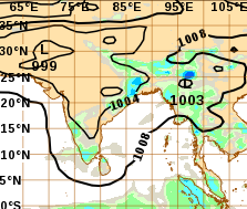
Bhubaneswar: Even as the well marked low is stationed over southwest and adjoining westcentral Bay of Bengal, weakening signs of the system are up.
Join the Whatsapp Channel to Get News updates in english
As per the synoptic analysis by models of Cooperative Institute of Meteorological Satellite Studies, the upper level divergence of the system has turned weaker than lower level convergence. This change in dynamic will lead to a rise in surface pressure, which in turn lead to weakening of the system.
Moreover, a glance at the analysis shows the system is now lying in an unfavourable deep shear region, which will be further blow to system’s consolidation pattern. The unfavourable shear may tear away the system.
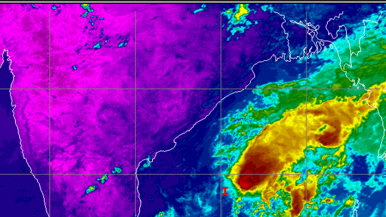
However, favourable Sea surface temperature, supportive MJO and equatorial Rossby waves, Kelvin waves will support the convective activities of the system leading to cloud formation. The cloud temperature (shown in dark red) has been measured at around (-) 70 deg C, showing the intense convective activities on.
The system will chart a north east direction from April 10 to dissipate over Myanmar.
Though the low pressure area will have no direct impact in inducing rainfall activities over the east coast of India, including Odisha, moisture incursion into land by the system’s wind into states like Andhra Pradesh and Odisha may trigger convective activities over the said states.
Andhra Pradesh may record convective rain on April 9, 10, 11 and 12.
ODISHA RAIN
Even as the State will not be witnessing low pressure induced rainfall, Odisha is predicted to receive good rainfall from April 15 onwards.
As per model predictions, the passing of a trough line from the trough formed over northeast through Odisha during the period of April 15 -19 will be bringing good amount of rainfall over the State.
Following the weather development, almost all major models such as IMD, ECMWF and ACCESS, predict rainfall at many places in the State.
Model predictions show the coastal regions in the State, including State Capital Bhubaneswar, will be recoding over 4 cm rains during the period of April 15-19.
Though rainfall activities have been predicted across the State, western districts will record light rainfall activities.
As a consequence, heat conditions will not be observed in coastal, north, central and south Odisha till April 18, though day time maximum temperature in western region of the State will hover around 38 deg C on some of the days till April 18.